Hurricane Iota Erupts To Category 5, “Catastrophic” Damage Expected
Tyler Durden
Mon, 11/16/2020 – 12:23
Update (1223 ET): Hurricane Iota strengthened into a Category 5 hurricane on Monday morning and is expected to make landfall in northeastern Nicaragua on Monday night or early Tuesday morning, the National Hurricane Center (NHC) said.
As of 1000 ET, Iota was located approximately 100 miles east-southeast of Puerto Cabezas, Nicaragua, with maximum sustained winds of 160 mph.
At Category 5, Iota is expected to be even more devastating than Hurricane Eta, which pulverized Central America earlier this month.
“This is a catastrophic situation unfolding for northeastern Nicaragua with an extreme storm surge of 15-20 ft forecast along with destructive winds and potentially 30 inches of rainfall,” the NHC wrote.
#Iota has become a category 5 hurricane and is forecast to bring catastrophic winds, life-threatening storm surge, and torrential rainfall to Central America. https://t.co/tW4KeFW0gB pic.twitter.com/w6oof46Ley
— National Hurricane Center (@NHC_Atlantic) November 16, 2020
* * *
Update (0515 ET): Powerful Hurricane Iota is headed toward the Nicaragua and Honduras coastline as a catastrophic Category 4 storm and could become a Category 5 on Monday.
The National Hurricane Center (NHC) said Iota has “rapidly strengthened overnight and now has 155 mph (245 km/h) sustained winds.”
“It could reach category five status later today before making landfall with 12-18 feet of storm surge,” NHC warned.
#Hurricane #Iota has rapidly strengthened overnight and now has 155 mph (245 km/h) sustained winds. It could reach category 5 status later today before making landfall with 12-18 feet of storm surge. More on this exceptionally dangerous situation: https://t.co/tW4KeFW0gB pic.twitter.com/gNGzvJlPUe
— National Hurricane Center (@NHC_Atlantic) November 16, 2020
Around 0500 ET, Iota was about 25 miles northeast of Isla De Providencia, Colombia, and moving west at ten mph. Landfall forecasts point to late Monday or early Tuesday morning.
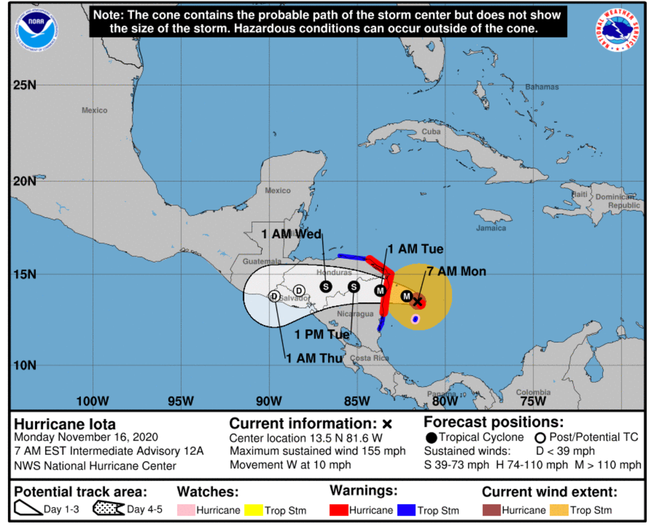
Iota could dump between 8 to 16 inches of rain in northern Nicaragua, Honduras, Guatemala, and southern Belize. Some areas could receive upwards of 30 inches. This comes weeks after Hurricane Eta battered the area in early November.
Iota is the 30th named storm of this year’s record-breaking Atlantic hurricane season.
* * *
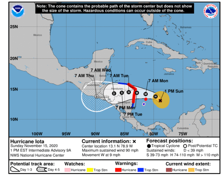
Iota strengthened to a hurricane Sunday over the southwestern Caribbean Sea, expected to “bring potentially catastrophic winds, a life-threatening storm surge, and rainfall impacts to Central America,” reported the National Hurricane Center (NHC).
#Hurricane #Iota is expected to become an extremely dangerous category 4 hurricane tomorrow and make landfall in NE Nicaragua or E Honduras. Preparations to protect life and property should be rushed to completion in the Hurricane Warning areas. More: https://t.co/tW4KeFW0gB pic.twitter.com/mK7SpNo0IF
— National Hurricane Center (@NHC_Atlantic) November 15, 2020
NHC’s 1000 ET Sunday update outlined how Iota is “rapidly intensifying” as it could be an extremely dangerous category 4 near the coasts of Nicaragua and Honduras.”
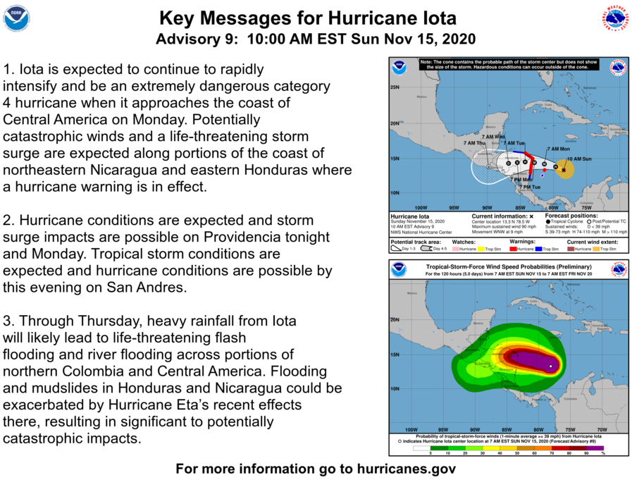
The current landfall forecast says tropical conditions will arrive on the coasts of Honduras and Nicaragua by Monday morning. “This is an extremely dangerous situation with Iota expected to be category 4 at landfall!” NHC warned.
Earliest Reasonable Arrive Time Of Tropical-Storm-Force Winds

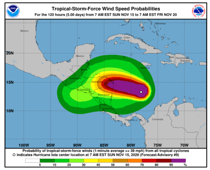
Wind Speed Probabilities
Hurricane Warning For Much Of Nicaragua and Honduras Coastline

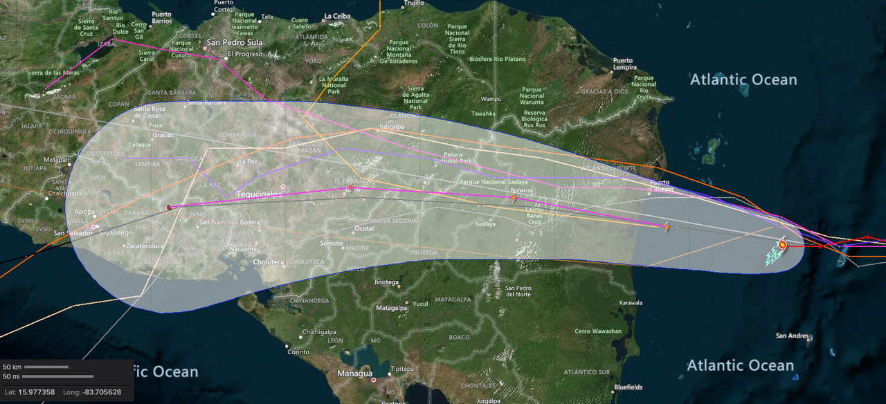
Hurricane Model
We explained on Saturday Iota would become a “major hurricane.” Weather models are forecasting the storm could dump 8 to 30 inches of rain on Honduras, northern Nicaragua, eastern Guatemala, and southern Belize by early next week.
In early November, Hurricane Eta battered the region (read: here & here), destroying upwards of 10% of the coffee crop in Central America, with Iota likely to push up the percentage to 25%.
![]()
Zero Hedge’s mission is to widen the scope of financial, economic and political information available to the professional investing public, to skeptically examine and, where necessary, attack the flaccid institution that financial journalism has become, to liberate oppressed knowledge, to provide analysis uninhibited by political constraint and to facilitate information’s unending quest for freedom. Visit https://www.zerohedge.com