“Winter-Like Chill” Targets East For Mother’s Day Weekend
Warming weather trends across the US over the last week forced many people out of their homes and into parks and beaches, to only ignore the government enforced stay-at-home public health orders. Now there’s a blast of frigid air that is expected to bring record-low temperatures in some areas for Mother’s Day weekend.
“The weekend cold will be the second of two shots of Arctic air spilling into the eastern half of the Lower 48 this week as a chillier-than-normal pattern that began in mid-April shows little sign of relenting. This abnormally cold weather marks a major departure from January through March when temperatures were much warmer than normal,” The Washington Post wrote.
EC operational forecasts show the frost line will dive this weekend into the Southern US and could impact crops, likely delaying some spring plantings.
“Temperatures may approach record cold levels for some areas with a late frost/freeze where the growing season has typically started,” wrote the National Weather Service (NWS).
“An amplified pattern will bring in late winter-like chill to much of the East later this week into the weekend as the West will see well above normal temperatures. Guidance remains in good agreement on one upper low swinging through the Great Lakes Friday and out of New England late Saturday with perhaps another one out of central Canada early next week close to Lake Superior. Blend of the deterministic guidance sufficed to start the period as low pressure deepens as it leaves the Ohio Valley toward the Maine coast by early Saturday. Weaker shortwave aloft and surface front will trail behind and bring in additional cooler air to the Plains and MS Valley this weekend, with the 18Z GFS/12Z ECMWF paired well with their ensemble means. By next Mon/Tue, pattern will start to break down.”
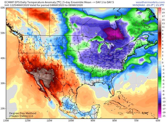
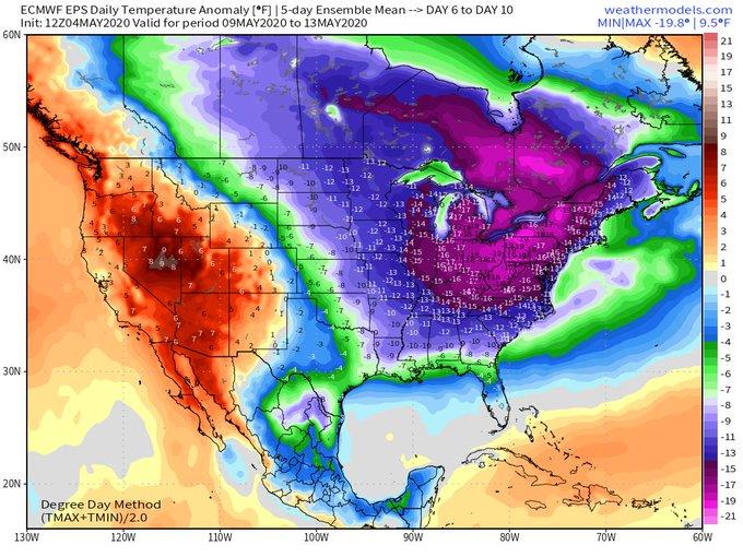
Meteorologist Ryan Maue tweeted, “Next 10-days look to be the coldest first-half of May in a long while. Average daily temperatures 10° to 20°F below normal across much of the Eastern US Actual highs will average in the 40s and 50s with overnight lows in the 20s and 30s.”
Temperature Anomaly Day 1 to Day 5
Temperature Anomaly Day 6 to Day 10
Michael Palmer, a meteorologist at the Weather Company, said the blast of cold air could produce record low temperatures for the Pittsburg area on Saturday.
The upcoming shot of May chill later this week means business. The Euro predicts temps around -10ºC at ~5,000 ft over Pittsburgh on Saturday morning. Even the “warmer” ensemble members are around -7ºC
The lowest May temp on record at that level is -9.3ºC (data since 1952). #pawx pic.twitter.com/wUdQo76cNv
— Weather World (@WeatherWorldPSU) May 4, 2020
https://platform.twitter.com/widgets.js
Heating degree day (HDD), the measurement designed to quantify the demand for energy needed to heat a building, is expected to surge for the Lower 48 by Friday and through the weekend. This means that cold weather could force many people in the Midwest, Southeast, and Northeast to turn on their heat this weekend. The good news is that warmer weather is expected to return in the second half of the month.
A 45 day HDD Lower 48 suggests that the blast of cold air this upcoming weekend will be the last of the year.
Summer is ahead…
Tyler Durden
Wed, 05/06/2020 – 05:30![]()
Zero Hedge’s mission is to widen the scope of financial, economic and political information available to the professional investing public, to skeptically examine and, where necessary, attack the flaccid institution that financial journalism has become, to liberate oppressed knowledge, to provide analysis uninhibited by political constraint and to facilitate information’s unending quest for freedom. Visit https://www.zerohedge.com


