Dramatic Satellite Imagery Shows Intense Wildfires Ravaging Western US
Dramatic satellite imagery shows the intense wildfires raging across the Western US, generating large smoke columns that have blanketed several states.
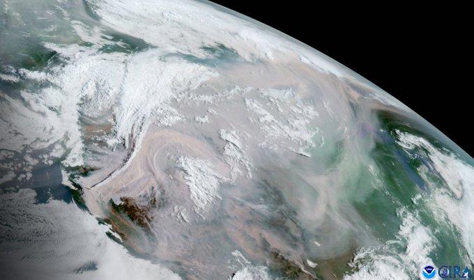
Cooperative Institute for Research in the Atmosphere’s Dakota Smith released what he says is “awful satellite imagery out of the West” last week that shows the extent of the “2021 Western wildfire disaster.”
Awful satellite imagery out of the West tonight.
The 2021 Western wildfire disaster continues. pic.twitter.com/MW2wEudmOq
— Dakota Smith (@weatherdak) August 17, 2021
According to the National Interagency Fire Center, more than 99 larger fires are burning in 12 states and have consumed more than 2.5 million acres.

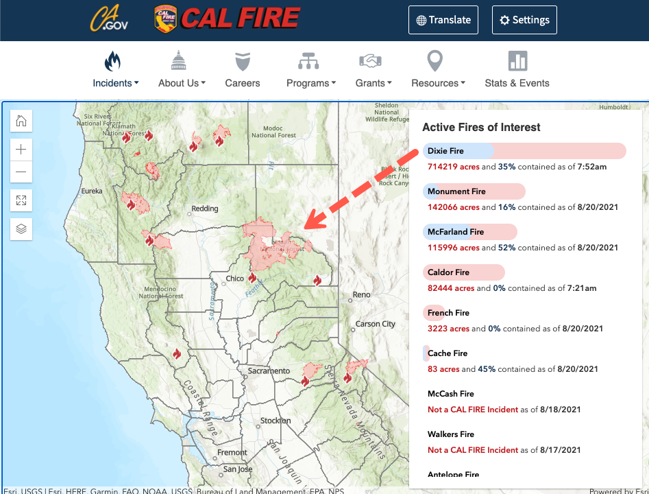
The largest active fire to date is Dixie Fire in Northern California. The California Department of Forestry and Fire Protection reported at 0752 local time that Dixie has burned 714,000 acres and is only 35% contained.
Smith tweeted a GIF satellite video of the Dixie Fire.
Close up of the Dixie Fire, showing extreme behavior. pic.twitter.com/Leu2ieP8Ot
— Dakota Smith (@weatherdak) August 17, 2021
He spots several wildfires in Oregon.
A view of the numerous wildfires in Oregon. pic.twitter.com/lECLkiOGlR
— Dakota Smith (@weatherdak) August 17, 2021
Smith shows wildfires are filling up California skies with smoke.
Quite incredible full day animation of the West wildfires. pic.twitter.com/DxW7pcAYWs
— Dakota Smith (@weatherdak) August 17, 2021
Smoke forecast models for Saturday morning show intense smoke across the West.
Start: Aug 21 6AM PDT
End: Aug 22 1AM PDT pic.twitter.com/XMVDtjMWSQ— HRRR Smoke Bot (@HRRRSmokeBot) August 21, 2021
Readers may recall in a weather note from May titled “California’s 2021 Fire Season Could Be “Like Armageddon,” Officials Warn” we quoted California’s top fire officials who warned, “conditions are already ripe for wildfires.”
What’s happening across the West is nothing short of historical, especially the Dixie Fire in California.
Tyler Durden
Sat, 08/21/2021 – 16:00
Zero Hedge’s mission is to widen the scope of financial, economic and political information available to the professional investing public, to skeptically examine and, where necessary, attack the flaccid institution that financial journalism has become, to liberate oppressed knowledge, to provide analysis uninhibited by political constraint and to facilitate information’s unending quest for freedom. Visit https://www.zerohedge.com